Service & Area
Quick Links
Karakorum & Himalayas
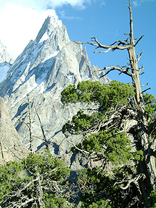
 The Karakorum is the apex of the mountain world; a spectacular wilderness of rock, black ice, sheer cliffs and foaming rivers. The range includes the mountains north of the lower Shyok, the Indus and lower Gilgit rivers as far west as the Ishkoman and Karamber valleys. The name Karakoram means ‘black rock’ in Turkic, an apt description of the mountains. No other range can boast such concentration of mighty peaks- three out of the six highest mountains in the world, five of the 8000m peaks 29 peaks above 7500m and 60 summits of over (6700m). Here is the earth’s second-highest mountain, K2 (8611m), the earth’s largest non-polar glacier, the Hispar-Biafo (76 miles - 122 km} from source to moraine, the earth’s greatest concentration of ice outside the Arctic and Antarctic, and the earth’s most spectacular mountain scenery.
 Most of the highest peaks are in the 300km long Great Karakoram range, which forms the main crest line of the entire system and is divided into sections from the Batura, Muztagh running east is the Hispar Muztagh, Panmah Muztagh and Baltoro Muztagh. The shorter range on either side of this great icebound crest is collectively termed the Lesser Karakoram range. On the north side are the Lupgar and Ghuzherav mountains. On the south side are the Naltar, Rakaposhi, Haramosh, Spantik-Sosbun, Mangom Gusor, Shimshal, and Masherbrum and Saltoro mountains.
What is true of the Lesser Himalayas is true also of the Greater Trans-Himalayas stretching for more that 1500 miles (2414 km) from Nanga Parbat (8126 m) on Indus to Namcha Barwa (7761 m) on the Brahmaputra. This is a world of giants whose names are familiar not only to mountaineers, but to millions of adventurers throughout the world. Here we find rare animals, the highest flowering plants and the highest inhabited dwellings.
Northern Areas
River Valleys & Agriculture
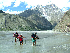
 In western Tibet two mighty rivers origin within a few miles of each other the Brahamaputra flowing east to Bhutan and the Indus flowing west through the Himalaya in a crescent, encircling the subcontinent through Tibet and Ladkkh before entering Baltistan, linking the culture and people of different regions. There are numerous tributaries that rise and fall to form a unique landscape of mountain chains , gorges and valley with contrasts. Most parts of these mountains are arid and receive very little monsoons . The snow and glaciers from these mountains are the source for an extensive network of rivers that cut deeply through them. The Braldu, Shigar, Shyok , Shimshal, Hunza, Ishkuman, and Ghizar rivers all of them flow to form the might Indus river, which, older than the mountains themselves, is the only river to flow through the Karakoram range. The central and upper Ghizar Rivers drain the Hindukush range and its offshoot, the Hindu Raj range. From the heavily glaciated Karakoram flow the Hunza and Shyok rivers, Nanga Parbat’s glaciers flow into the Indus River, which separates this Himalayan massif from the Karakoram.
Village life follows a pattern of subsistent agriculture where every bit of land is utilized combined with animal husbandry. Corn, buckwheat and millet are staple crops with low lying valleys producing some rice and vegetables with potatoes as cash crop . Cultivation is done through intensive irrigation possible from canals cut across sheer cliffs and scree slopes that are engineering marvel. Its possible to grow two crops per year as high as 2400m, . Sheep and goats are raised in most places along with milk cows. Bulls are used for plough-ing and threshing, yoked together and driven over harvested grain. Yaks are the favored livestock at higher altitude.
![]()
![]()
Copyright © Hindukush Trails, All Rights Reserved.
Website Designed & Developed by Yor Solutions