Afghan Hindukush Pamir & Wakhan Nuristan
 Since 1997 each year, Hindukush Trails did extensive exploration in the Afghan Pamirs and Hindukush, right into Wakhan and Badhkashan. Route maps ( when non exited ) were sketched out for own use with extensive details, these are now useful for the benefit of others who followed.
Mountains dominate most of the landscape of Afghanistan with more than 49 percent of the total land area lying above 2,000 meters.
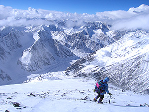
In the north on the Wakhan corridor the Pamirs merge into the Hindukush , where they are still being born, still thrusting up at the rate of something like two-and-a-half inches a year. Yet in the very moment of their birth, they are dying, for the ranges to the southeast are rising even faster and each year are blocking off more and more of their already inadequate rainfall, converting their already barren slopes to desert. This is one of the bleakest and least-known corners of the world , remote, mysterious and at one time, dubbed ‘the third pole’. The Pamir mountains, which Afghans refer to as the 'Roof of the World," extend into Tajikistan, China and the Karakorums. In Wakhan these mountains are rounded domes, divided by high, wide valleys which are very nearly as desolate as the peaks that surround them.
 Although geographers differ on the division of these mountains into systems, they agree that the Hindukush system, the most important, is the westernmost extension of the Pamir Mountains, the Karakorum Mountains and the Himalayas. The Hindukush mountain peaks in the eastern part of the country reach more than 7,000 meters. The highest of these is Noshaq at 7,485 meters.
The mountains of the Afghan Hindukush diminish in height as they stretch westward toward the middle, near Kabul, they extend from 4,500 to 6,000 meters, in the west they attain heights of 3,500 to 4,000 meters. The average altitude of the Afghan Hindukush is 4,500 meters. The Hindukush mountain system stretches for about a 1000km south but only about 600 kilometers of the system is called the Hindukush mountains, the rest consists of numerous smaller mountain ranges like the Koh-e-Baba, Salang, Koh-e Paghman, Spin Ghar or Safid Koh, Suleiman, Siah Koh, Koh-e Khwaja Mohammad, Selseleh-e-Band-e-Turkestan.
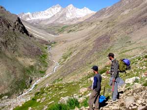 Numerous high passes connect the mountain valleys through which trade caravans travel. The most important passes are Salang (3,878 meters); it links Kabul and points south to northern Afghanistan. The Khyber Pass (1027 meters), into Pakistan, the Wakhjir (4,923 meters), in the Wakhan Corridor into Xinjiang, China, the Khawak pass 3550m into Panjsher valley, the Baroghil (3,798 meters) and Dorah into Chitral Pakistan. These mountainous areas are mostly barren, or at the most sparsely sprinkled with trees and stunted bushes. True forests, found mainly in the eastern provinces of Kunar , Nuristan and Paktiya cover barely 2.9% of the country's area. Even these small reserves have been disastrously depleted by the war and through illegal exploitation.
River Valleys
 Afghanistan consists of 652,290 sq. miles territory which is completely landlocked. It is bordered by Iran to the west , by the Central Asian States of Turkmenistan, Uzbekistan, and Tajikistan to the north and northeast , by China on the Wakhan Corridor and Pakistan to the east and south .
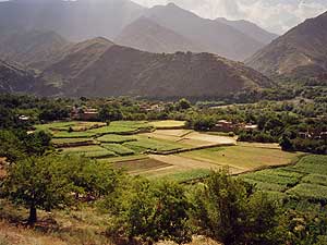
Afghanistan possesses both mountains, lakes, river valleys and desert areas. The four major river systems are the Amu Darya, the Oxus 1,100km in Afghanistan the Hilmand (1,300 kilometers); the Harirud (650 kilometers in Afghanistan and the Kabul (460 kilometers). Many rivers and streams simply empty into arid portions of the country, spending themselves through evaporation flowing seasonally and only the Kabul flows into the Indus in Pakistan and thence into the Arabian Sea.